Hello World Wind
World Wind is a virtual globe, developed by NASA, it gives us the ability to add Google Earth like functionality to our applications.
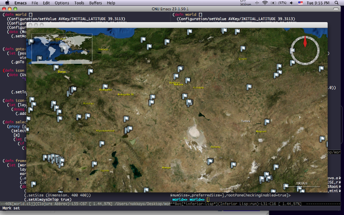
In my previous post Mashups Using Clojure, I produced a HTML file and used Google Maps to visualize the data, with world wind we can integrate the map directly into the application.
I am going to be using the same parsing routines that I used for the Mashups Using Clojure post so I am going to skip explaining those and jump directly to World Wind stuff.
(ns world
  (:use clojure.contrib.str-utils)
  (:use clojure.contrib.duck-streams)
  (:use clojure.contrib.prxml)
  (:import  (java.net URL)
            (java.io BufferedReader InputStreamReader)
            (java.awt Dimension)
            (gov.nasa.worldwind Configuration WorldWind)
            (gov.nasa.worldwind.avlist AVKey)
            (gov.nasa.worldwind.awt WorldWindowGLCanvas)
            (gov.nasa.worldwind.geom LatLon Position)
            (gov.nasa.worldwind.view.orbit BasicOrbitView)
            (gov.nasa.worldwind.layers IconLayer)
            (gov.nasa.worldwind.render UserFacingIcon)
            (gov.nasa.worldwind.event SelectEvent)))

(defstruct earth-quake
  :date :time :latitude :longitude :depth :md :ml :ms :location)

(defn fetch-url[address]
  (let  [url (URL. address)]
    (with-open [stream (.openStream url)]
      (let  [buf (BufferedReader.
                  (InputStreamReader. stream "windows-1254" ))]
        (apply str (interleave (line-seq buf) (repeat \newline )))))))

(defn parse [data]
   (map
    #(apply struct earth-quake (re-split #"\s+" % 9))
    (re-split #"\n+" data)))

(defn eartquakes []
  (let  [page (fetch-url "http://www.koeri.boun.edu.tr/scripts/lst9.asp")
         data (re-find #"(?s)------------    -----------\n(.*?)</pre>" page)]
    (parse (data 1))))
First you need to get the latest SDK, unzip it and copy the jar and library files in to your Java extensions folder, if you put them somewhere else on your classpath don't forget to set your library path to point to the native libraries.
(defn world []
  (Configuration/setValue AVKey/INITIAL_LATITUDE 39.3113)
  (Configuration/setValue AVKey/INITIAL_LONGITUDE 32.8038)
  (Configuration/setValue AVKey/INITIAL_ALTITUDE 1000000)
  (doto (WorldWindowGLCanvas.)
    (.setModel (WorldWind/createConfigurationComponent
                AVKey/MODEL_CLASS_NAME))))
The component that holds the world is called WorldWindowGLCanvas, you don't need to set any initial values but you need to set the model.
(defn goto-pos [world lat long elev]
  (let [position (Position. (LatLon/fromDegrees lat long) (* elev 10000))
        view (cast BasicOrbitView (.getView world))]
    (.goTo view position (* elev 10000))))
If later on you want to change the orientation of the map, fly to a different location, you can call goTo method of the view but beware, if you try to use it before the map is shown in a frame it won't work, configure initial values instead.
(defn icon [quake]
  (doto (UserFacingIcon.
         "icon.png" (Position.
                     (LatLon/fromDegrees (Double. (:latitude quake))
                                         (Double. (:longitude quake))) 0.0))
    (.setToolTipText (apply str (interleave quake (repeat " "))))))
In order to mark positions on the map, world wind provides UserFacingIcon class, it takes an image for the icon and the coordinates to place the icon.
After creating the icons you need to put them on a IconLayer,
(defn icon-layer [icons]
  (let [layer (IconLayer.)]
    (doseq [icon icons]
      (.addIcon layer icon)) layer))
By default icons don't work like markers in Google Earth, you can't click on them, to capture events that are happening on the map, we need to install a SelectListener and check if the event occurred on a UserFacingIcon, if so we toggle it's tooltip.
(defn select-listener []
  (proxy [gov.nasa.worldwind.event.SelectListener] []
    (selected
     [e]
     (let [object (.getTopObject e)]
       (if (= (.getEventAction e) SelectEvent/LEFT_CLICK)
         (if (instance? UserFacingIcon object)
           (.setShowToolTip object (not (.isShowToolTip object)))))))))
Thats all it takes to create our mashup, we need to create the world, create a icon for each earthquake, place them on a layer and add it to the world,
(defn frame []
  (let [world (world)
        layers (.getLayers (.getModel world))
        earth-quakes (map #(icon %) (eartquakes))]
        (.add layers (icon-layer earth-quakes))
        (.addSelectListener world (select-listener))
        (doto (javax.swing.JFrame.)
          (.add world)
          (.setSize (Dimension. 400 400))
          (.setAlwaysOnTop true)
          (.setVisible true))))