GPS Traces Using World Wind
I have a lot of GPX files lying around from various biking trips. I don't have much use for them other than loading them in to Google Earth and brag about being there and done that, so I thought I would parse the file myself and paint the route on the World Wind.
GPX files are XML files, containing the coordinates you have been to, if you draw a line through these points you can rebuild the route you have taken.
(ns gpx
  (:require [clojure.zip :as zip]
            [clojure.xml :as xml])
  (:use clojure.contrib.zip-filter.xml)
  (:import (java.util ArrayList)
           (java.awt Dimension)
           (gov.nasa.worldwind.layers RenderableLayer)
           (gov.nasa.worldwind.geom LatLon Position)
           (gov.nasa.worldwind.render Polyline SurfacePolyline)
           (gov.nasa.worldwind.avlist AVKey)
           (gov.nasa.worldwind.awt WorldWindowGLCanvas)
           (gov.nasa.worldwind Configuration WorldWind)))

(defn points [f]
  (let [data (zip/xml-zip (xml/parse f))
        trkpt (xml-> data :trk :trkseg :trkpt)]
    (map #(vector (attr % :lat)
                  (attr % :lon)
                  (first (xml-> % :ele text))) trkpt)))
gpx=> (take 2 (points "data.gpx"))
(["41.011934" "29.196977" "154.909546"]
 ["41.010155" "29.195925" "150.583618"])
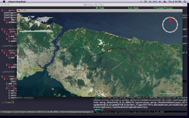
This will return a sequence of vectors, each containing three items, latitude, longitude and elevation of the point. To draw a path on to the map World Wind provides two classes SurfacePolyline and Polyline. SurfacePolyline will draw a flat line on to the surface between coordinates where as Polyline draws a GL line between positions, which includes elevation data.
(defn world []
  (Configuration/setValue AVKey/INITIAL_LATITUDE 39.3113)
  (Configuration/setValue AVKey/INITIAL_LONGITUDE 32.8038)
  (Configuration/setValue AVKey/INITIAL_ALTITUDE 1000000)
  (doto (WorldWindowGLCanvas.)
    (.setModel (WorldWind/createConfigurationComponent
                AVKey/MODEL_CLASS_NAME))))

(defn surface-polyline [points]
  (let [list (ArrayList.)]
    (doseq [p points]
      (.add list (LatLon/fromDegrees (Double. (p 0)) (Double. (p 1)))))
    (doto (RenderableLayer.)
      (.addRenderable (SurfacePolyline. list)))))
To create a SurfacePolyline, we need to create a list of LatLon objects and pass that to the SurfacePolyline constructor at this point you can also set a color for the line then we create a RenderableLayer and add our SurfacePolyline to it, this final layer is what will be added to the World Wind canvas.
(defn polyline [points]
  (let [list (ArrayList.)]
    (doseq [p points]
      (.add  list (Position.
                   (LatLon/fromDegrees (Double. (p 0)) (Double. (p 1)))
                   (Double. (p 2)))))
    (doto (RenderableLayer.)
      (.addRenderable (Polyline. list)))))

(defn frame []
  (let [world (world)
        layers (.getLayers (.getModel world))]
    (.add layers (surface-polyline (points "data.gpx")))
    ;;(.add layers (polyline (points "data.gpx")))
    (doto (javax.swing.JFrame.)
      (.add world)
      (.setSize (Dimension. 300 300))
      (.setAlwaysOnTop true)
      (.setVisible true))))
Process of creating a Polyline is the same, the only difference is instead of building a list of LatLon objects, we build a list of Position objects which includes the elevation data, again we get a layer that is ready to be added to the world.